Apr 12,2022 – Anıl ÜYE & Arzu ÇUBUKÇU


Data science is an interdisciplinary field that employs scientific methods, processes, algorithms, and systems to obtain information and insights from structured and unstructured data, as well as to solve analytically complex problems with data. Businesses in aerospace and other industries are increasingly relying on data science to address new opportunities and boost productivity in a variety of fields.
Future aviation will necessitate the implementation of new procedures and technologies by air traffic controllers, operators, and researchers in order to create an efficient and environmentally friendly air transportation network. Data analytics and machine learning (ML) techniques are becoming increasingly useful in aviation for extracting information from large amounts of data produced, predicting future situations based on historical data, and aiding in making the right choice.
Deep learning is a subfield of machine learning that uses artificial neural networks algorithms to work with multidimensional data in multilayer architectures. Image processing and visual object detection have advanced dramatically as a result of deep learning methods.
Haritaevi works to reduce the environmental impact of airport activities, to prepare sustainable environments, and to develop new innovations. In this context, Haritaevi has conducted a demonstration study that can process the image of the signs on the airport’s taxiway and predict a high success rate.
The study established a deep learning model that processes images using deep learning libraries and technologies such as Tensorflow, Keras, and OpenCV, and then a data library was created using the Haritaevi database and other relevant resources. The application is based on matching the specified image with the correct output and measuring the accuracy of this match for the accuracy test of the established model.
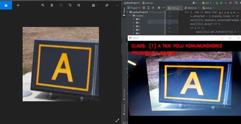
A sample image was chosen for each marker specified for the application’s test outputs and tested with a real-time camera. The printouts include estimation and accuracy rates for the images. There is a linear relationship between the size of the libraries created for each image, the image quality, and the output success rate. The study’s scope and success can be expanded by increasing the diversity, quality, and quantity of data collected.
The detection of runway markings and foreign objects is an important issue that must be addressed in the field of aviation safety. Furthermore, the fact that this detection process can be performed in real time makes it even more valuable. As Haritaevi, we monitor developments in the field of aviation safety and intend to expand our product and solution offerings in this area. We believe that any investment in safety will pay off, and we work hard to make that happen.