October 26, 2023 – Arda DURMUŞ

With the rapid development of the aviation industry and increasing air traffic, aviation safety has never been more critical. Natural terrain obstacles around airports can pose significant hazards during aircraft during aircraft approaches and takeoffs. Detecting and mitigating these obstacles is a fundamental requirement of civil aviation, but this essential task is challenging without the assistance of technology.
Natural terrain obstacles around airports, such as mountains, high hills, and valleys can create a serious risk for aircraft during takeoff and landing. Low-altitude flights around these obstacles can cause potential accidents and put human lives at risk.
Aviation safety takes various measures to minimize such risks, and one of these measures is identifying natural terrain obstacles penetrating the Obstacle Limitation Surfaces (OLS) around airports, integrating this data into Terrain Awareness and Warning Systems (TAWS), and adjusting flight routes accordingly. This is where NASADEM_HGT and ALOS AW3D30 come into play.
NASADEM, provided by NASA, is a globally available dataset that offers terrain topography data worldwide. It is an open-source geospatial dataset that provides high-quality and precise data, an improved version of data collected during the Shuttle Radar Topography Mission (SRTM), and plays a critical role in aviation safety. For more information, you can visit The Land Processes Distributed Active Archive Center (LP DAAC).
ALOS AW3D30, provided by the Japan Aerospace Exploration Agency (JAXA), is another open-source dataset produced for the same purpose and very similar to the NASADEM. For detailed information, you can visit: ALOS Global Digital Surface Model
One of the most outstanding features apart from its competitors is providing digital land topography data at high spatial resolution in global coverage and making it accessible to everyone as open data. You can also access the great case study in Brazilian Cerrado from here that examines the conformity of the NASADEM_HGT and ALOS AW3D30 DEM with the Altitude from the Brazilian Geodetic Reference.
These are the common key benefits that these datasets, which are among the most important geospatial open data sources, for airports and aviation safety:
High Resolution: Provides detailed terrain information with a 30-meter spatial resolution, making it highly useful for detecting natural terrain obstacles around airports and providing the necessary details for safe takeoffs and landings.
Global Coverage: Covers terrain topography worldwide, making it applicable to various geographic locations of airports and improving aviation safety on a global scale.
Suitable for Research and Analysis: Digital Elevation Model open data serves as a powerful tool for aviation authorities, aviation engineering services, and researchers. These data can be used to understand the risks around airports and improve aviation safety on a global scale.
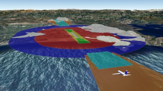
Haritaevi provides the creation of Obstruction Identification Surfaces (OIS) based on the ICAO Annex 14 (OLS – Obstacle Limitation Surfaces) and Annex 15 specifications (Areas 2a, 2b, and 2c) in order to ensure the removal of obstacles around airports to conduct safe flight operations. Utilizing the Digital Elevation Models, analyze and identify natural terrain obstacles that penetrate these surfaces, and present this data to users through the OBSTACLEANALYZE web application according to their contracts and subscriptions.
When the eyes turn from the sky to the Earth, aviation safety begins with the detection of natural terrain obstacles around airports. Powerful datasets like NASADEM_HGT and ALOS AW3D30, available for free on a global scale, assist the aviation industry in fulfilling this critical task. With such technological advancements and highly accurate spatial open-source datasets shared, the aviation world can further enhance passenger and equipment safety.


